NRCS Press Release:
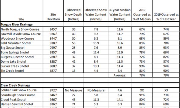
Sheridan County snowpack Snow Water Content is below median this week as spring seems to have arrived for most of Sheridan County. Snowpack water content ranges from 67% to 91% of median across the eastern Bighorns.
Composite snow-water data from Snotel and manually collected snow-course sites indicate the Tongue River drainage snow water is below median, at 78%. Clear Creek snow water is somewhat higher at 86% of median, from the same composite of snow-course and Snotel data. The entire Powder River Basin, including Clear Creek, indicates marginally higher snow-water, at 89% of median based on Snotel data in the basin.
Tongue River and Powder River watersheds both have substantially lower snowpack water content than at this time last year, with percent of last year values at 79% and 65%, respectively. Total Water Year to Date Precipitation at Snotel sites in both basins are below average as well, at 74% each. Across Wyoming Snotel data indicate most river basins were near or above median as of April 1st, with the southeastern basins being highest after the heavy snows last month.
The Lower North Platte River basin is the highest in the State at 129% of median. The three north central basins, the Bighorn, Powder and Tongue hold the lowest percent of median values in the State, at 89%, 89% and 80% of median respectively.
Snotel data included in this report was current on April 1st. Manual snow course data included in this report was collected March 27th to 29th. Snotel data collectors are permanent, remote sites that transmit real-time snow water content and precipitation data through a west-wide computer network.
Daily data from these sites, as well as other water supply-related reports and products can be accessed through the Water link under Topics on the Wyoming NRCS Homepage at www.wy.nrcs.usda.gov.


